The lower end of the Afon Mellte, flowing through a deep valley, partly cliff-lined, with big waterfalls and cascades. Part is followed by wide paths, past the ruins of the Glyn Neath Gunpowder Works; further upstream is harder to explore
The Afon Mellte is one of the major rivers of Brecon Beacons National Park's Waterfall Country, north of Pontneddfechan, famous for the section north of the confluence with the Afon Hepste, along which are three large waterfalls and a cave. South of the confluence, the lower 2 miles of the Mellte are less well-known since much has no marked path, though the southernmost section, shortly before the Mellte meets the River Neath, is followed by several paths, accessing the dispersed ruins of the Glyn Neath Mills, or Gunpowder Works, once a major operation, until closure in 1931.
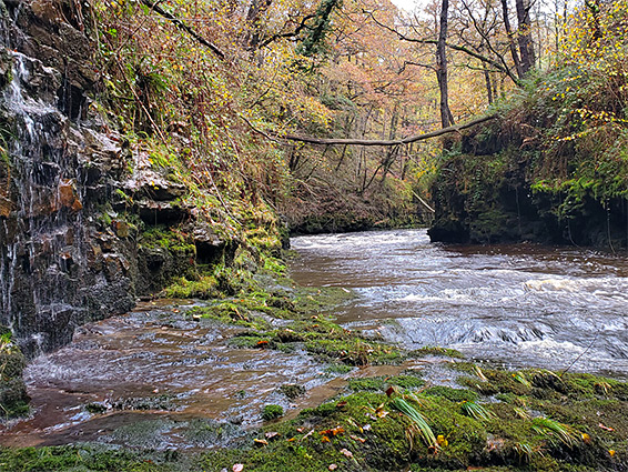
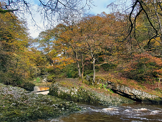
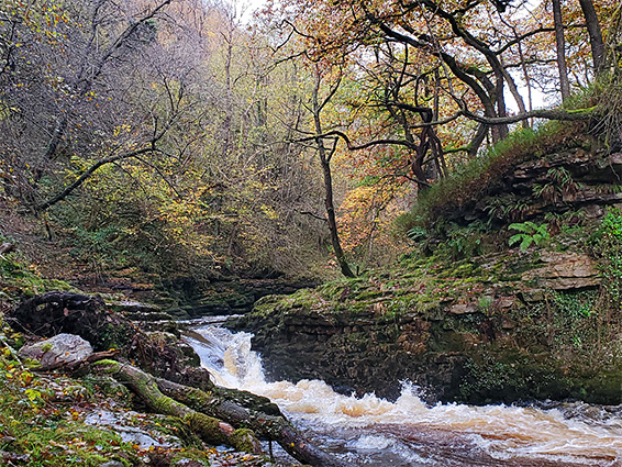
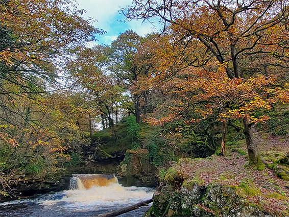
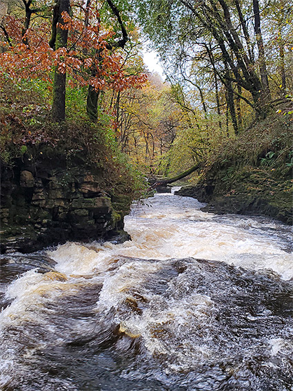
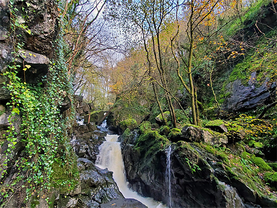
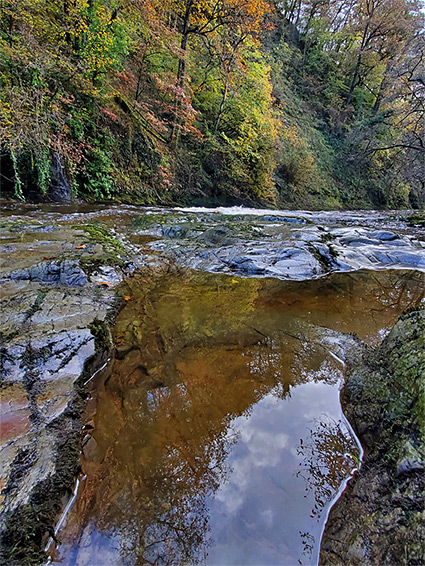
Attractions of this area are twofold - viewing the various ruins and relics of the gunpowder works, which include bridges, weirs, tramways, buildings and a leat, and also exploring the gorge, the most scenic part of which is the one mile between the works and the Hepste confluence. Here the river is coursing through a deep valley with steep, wooded sides, partially cliff-lined at river level, with a number of powerful cascades, and several tributary drainages that also form waterfalls. All is moist and shady all year, good for a range of mosses, lichens and other plants.
That is no official path through here though a faint route does lead up the gorge, on the west side, generally at or close to river level, but climbing quite high above in a few places, to avoid cliff-bound sections. It eventually reaches a flat area by the Hepste confluence then seemingly climbs to the rim of the plateau above, since further upstream the western side of Mellte valley becomes too steep to traverse.
Although relatively short, walking the trail beyond the gunpowder works is slow due to the steep and unstable ground, and since there is a lot to see, including the ruins, the round-trip can take most of one day. The scenery is photogenic and quite spectacular.
A suitable parking place for the Afon Mellte Gorge is at Dinas Rock, or Craig y Ddinas, a former quarry site at the confluence of the Mellte and another major tributary, Afon Sychryd, which also has confined sections, and waterfalls. There is no charge for parking though the place can become full at busy times, and it is locked at dusk, partly to prevent overnight camping. Two paths start here - a short walk up the lower end of the Sychryd to a waterfall, and the Sgwd yr Eira Trail, accessing a famous waterfall along the Afon Hepste, one seen from the opposite (north) side via the Four Waterfalls Loop. Glyn Neath Mills and the Afon Mellte can be accessed either via two paths that fork northwards off this route, descending a slope and crossing the river on footbridges, or alternatively by walking back down the car park access road a short distance, over the road bridge to the north side, and then along a track, once the vehicular route to the gunpowder works.
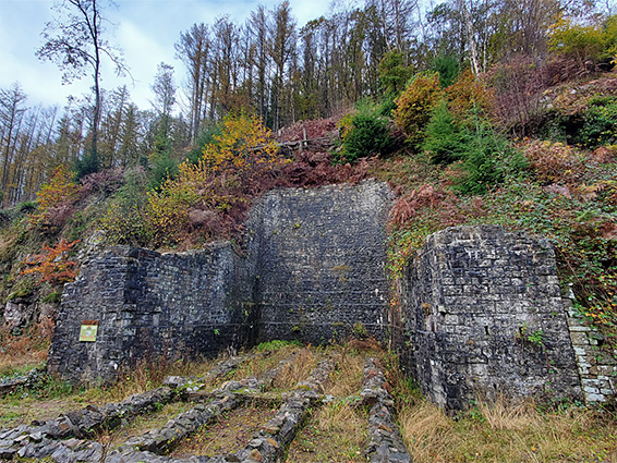
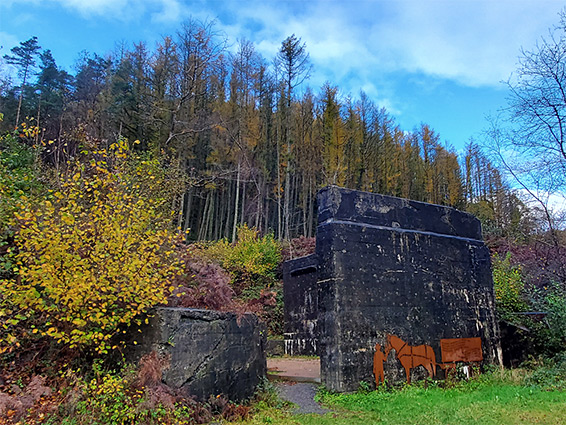
Glyn Neath Mills was established in 1857, providing black powder for use in mines and quarries. The various buildings and other sites were spread out for 1.6 miles, mostly on the north bank of the Mellte, water from which was employed to drive waterwheels and turbines. The place closed when black powder was banned from coal mines after a series of accidents, and many of the buildings were swiftly demolished, to prevent accidental explosions due to residual powder, and yet plenty of structures remain. In addition to the access road, the works were served by a tramway, one branch of which crossed the river to a quarry on the south side, and also by an aqueduct, or leat, also crossing the river; both crossings are now used as bridges for the two paths that connect with the Sgwd yr Eira Trail.
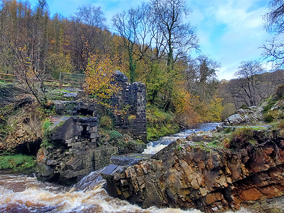
The easternmost of the linking paths, over the tramway bridge, crosses the Mellte just downstream of a dramatic section of the river, centred on a large rock, connected to the south bank by a weir, while on the other side is a masonry-lined channel, and more ruined walls above. Just upstream of here are several of the largest remaining buildings from the gunpowder works, at the upper end of the main portion of the site, though a path continues a little further, through a patch of trees, following the former tramway, to the site of a bridge that took this route to the opposite side of the river, where it continued for a quarter of a mile. This bridge however is long gone and the official path ends here; a notice states as much, however an obvious trail does continue, 500 feet, to a weir, another relic of the gunpowder works.
North of the weir the valley sides are steepening, and only a very faint path continues, reaching the Afon Hepste confluence in 0.8 miles, a route that passes cascades, waterfalls, cliffs, ledges and enclosed channels. The way ahead is not always obvious, and the path can be difficult to follow. The river is usually flowing much too fast and deep to cross so there is no way to link with the Four Waterfalls Loop. The latter stages of this path cross flatter land, as the valley floor is now rather wider, and the riverside trail ends with a traverse of a grove of trees, right opposite the confluence. After here the faint path continues by climbing steadily, heading towards a conifer plantation on level ground on the plateau above.